
In this post
How does Earth Observation move from a map to a decision in development finance? In the Dominican Republic, the World Bank used ESA’s GDA Fast EO Co-Financing Facility to integrate satellite-based risk evidence into the way hydrometeorological risk is assessed for planning and investment. The result is not a one-off study, but a set of operational baselines and risk products designed to support ongoing use:
-
a nationally scalable methodology for flood and landslide risk mapping across 14 provinces, even where historical records are incomplete
-
the country’s first flood event inventory, reconstructed from Sentinel-1 and national meteorological data
-
risk profiles for seven critical infrastructure zones, linking hazards to exposure and vulnerability to help prioritise resilience investments
Together, these outputs strengthen the evidence base that development finance relies on: risk screening, project design, investment prioritisation and clearer coordination with national authorities.
Turning storm seasons into measurable risk data
Across the Caribbean, hurricane season brings a familiar rhythm: around 14 named storms each year, roughly seven hurricanes and three major hurricanes (Category 3 or higher). For the Dominican Republic, the impact often arrives early. Sitting in the main corridor of Atlantic tropical storms, the country is exposed not only to high winds, but to highly variable rainfall and steep terrain that can quickly turn intense precipitation into flash floods and landslides.
Some years, rain falls in violent bursts. In others, drought can last for months. And in between, the same river basins that were dry days earlier can suddenly swell, while slopes give way after persistent rain. Families, businesses, hospitals, schools, roads and farmland live with this instability as a fact of life.
National authorities have long understood these risks. But disaster management has been constrained by a common challenge in development contexts: risk information is often fragmented, incomplete, or uneven across regions. Without consistent national baselines, it becomes difficult to compare risk across provinces, validate models and move from reactive response toward prevention, preparedness and targeted investment.
Rebuilding the risk baseline with Earth Observation
Through the ESA GDA FFF, the World Bank sought to strengthen the Dominican Republic’s foundational understanding of hydrometeorological risk. The objective was clear: integrate Earth Observation (EO) into risk analysis processes that can support development planning, infrastructure investment and long-term resilience strategies.
ESA’s GDA FFF company lead Earthpulse supported this effort by combining European EO data with national and local datasets to build a coherent and transparent picture of flood and landslide risk across 14 provinces. The work focused on creating a scalable baseline that can be updated over time and used to inform both World Bank operations and national decision-making.
The project was structured in two complementary phases: first, establishing a national inventory and methodology; then translating it into actionable risk profiles for critical infrastructure.
Phase 1: Building the first comprehensive risk inventory for floods and landslides
Phase 1 began with a practical question: what information exists, what is missing and what approach is feasible in a country where hazards evolve quickly and records are uneven?
The assessment identified several structural limitations:
-
no consistent national landslide event catalogue
-
no comprehensive flood event inventory
-
limited availability of high-resolution precipitation data
-
insufficient high-resolution digital elevation models in most regions
These gaps matter directly for development finance. When event catalogues are incomplete and baselines are inconsistent, risk cannot be compared reliably across locations. That makes it harder to prioritise investments, justify resilience measures and design interventions that match real exposure.
To address these constraints, EO-based hydrological and multi-criteria approaches were evaluated, combining satellite observations, global services and locally available datasets. The result was a nationally scalable methodology for flood and landslide risk mapping that can operate even when historical records are incomplete.
A roadmap was also defined for the progressive development of an EO-enabled Early Warning System, combining continuous satellite monitoring and institutional collaboration to support governance and uptake. The work aligned directly with the Sendai Framework priorities on understanding disaster risk and strengthening risk governance.
By the end of Phase 1, the Dominican Republic had, for the first time, a structured and transparent national baseline of hydrometeorological risk, a foundation that can support risk screening, investment prioritisation and resilient infrastructure planning.
Phase 2: Turning the baseline into actionable risk profiles for critical infrastructure
If Phase 1 established the “national picture”, Phase 2 focused on what decision-makers often need next: where to act first and how to protect critical assets.
Phase 2 translated Phase 1 findings into actionable risk assessments for seven critical infrastructure zones, each analysed within a 15 km radius. The innovation of this phase lies in building risk models tailored to the Dominican Republic’s complexity, integrating European EO with local administrative and socioeconomic datasets.
Reconstructing extreme flood events with EO
Using a blend of ONAMET meteorological station data and Sentinel-1 radar imagery, the team identified six extreme rainfall events between 2017 and 2024. EO made it possible to map how water expanded across plains, urban areas and river basins, including flood signatures linked to events that had gone undocumented for years.
This work resulted in the first flood event inventory for the country, providing foundational evidence for emergency planning, infrastructure protection and World Bank-supported risk assessments.
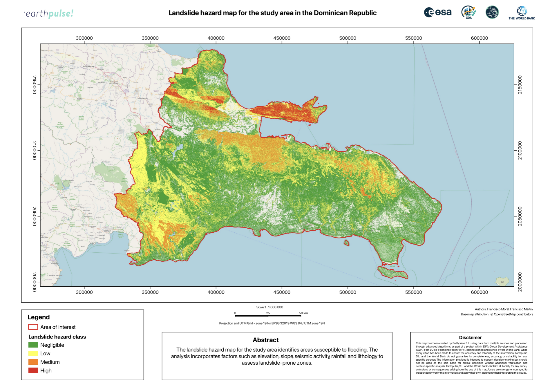
Validating landslide susceptibility where records are incomplete
For landslides, local authorities contributed a partial event inventory, though dates were often missing. Even so, the spatial distribution of reported landslides showed strong agreement with EO-derived susceptibility maps, helping validate the multi-criteria approach.
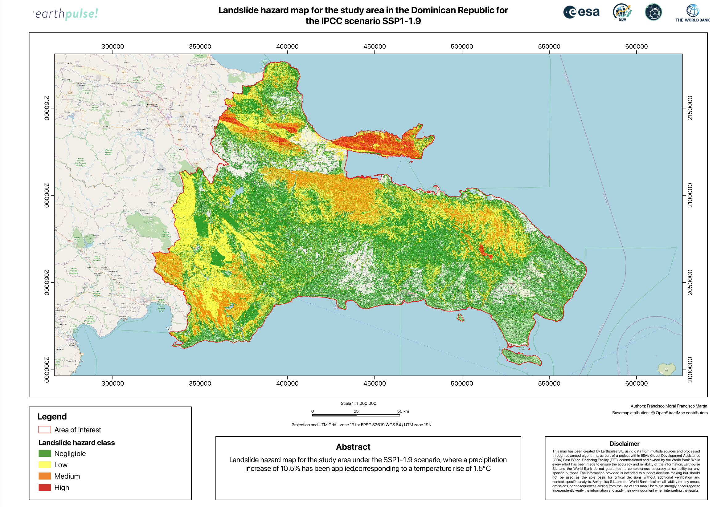
Landslide modelling integrated slope, lithology, land cover, rainfall and seismic triggers. To explore how future conditions could shift risk, the analysis also used climate projections based on IPCC data and ERA5 rainfall trends.
Moving from hazard maps to investment-relevant risk information
To move beyond hazard mapping, EO outputs were combined with socioeconomic and infrastructure datasets, including population layers, road networks and vulnerability indicators. This integration allowed the assessment of not only where hazards occur, but what assets and communities could be affected.
For each infrastructure zone, tailored risk profiles were produced, including:
-
hazard and susceptibility maps
-
exposure and vulnerability indicators
-
composite risk assessments
recommendations for future Early Warning System integration

These profiles support national authorities and the World Bank in prioritising investments, strengthening project design and targeting resilience measures where they are most needed.
What EO uptake looks like in development finance
This project shows how EO can be used as an operational input, not an add-on. By reconstructing missing risk information and translating EO insights into decision-ready products, the work can support key steps in IFI workflows, including:
-
risk screening and project prioritisation, especially where historical records are incomplete
-
project design and appraisal, by identifying where hazards, exposure and vulnerability overlap
-
resilience investment planning, using comparable risk profiles around critical assets
-
monitoring and reporting over time, with baselines that can be updated as new EO data becomes available
-
early warning pathways, by linking a national baseline to a roadmap for continuous monitoring and institutional collaboration
For the World Bank, the EO-derived datasets and methods provide a replicable foundation that can inform future programmes and routines in the Dominican Republic and similar contexts.
Why this story matters
The Dominican Republic’s challenge is increasingly common: resilience is often limited less by the absence of solutions than by the absence of complete, comparable risk knowledge. When baselines are fragmented, it becomes harder to make confident choices about where to invest, what to protect and how to measure whether interventions are working.
This project shows how Earth Observation, combined with national and local expertise, can help reconstruct how landscapes behave during extreme events, even where historical records are limited. That evolving understanding becomes a practical tool for protecting communities, safeguarding infrastructure and supporting faster, more informed decision-making.
Through the ESA GDA Fast EO Co-Financing Facility, the work delivered the first unified, evidence-based understanding of hydrometeorological risk across the Dominican Republic, alongside a framework designed to grow with every new satellite image, every new rainfall event and every new piece of local data.
The approach is designed to be transferable, across the Caribbean and across other IFI-supported programmes where floods, landslides and storms increasingly converge. The story is ongoing and that is precisely its strength: it establishes a foundation on which preparedness and resilience can continue to build.
About the Author: Francisco Moral
With more than 20 years of experience in the Earth observation sector, Francisco (also known as Paco) fuses satellite imagery, geospatial data, and advanced analytics to navigate some of the most pressing global challenges, from climate change to biodiversity loss, and resource exploitation. His work reveals the hidden dynamics of our planet, from urban expansion and shifting water resources to broader environmental transformations. The goal is to translate complex Earth data into actionable insights that support sustainable decision-making and a deeper understanding of Earth’s interconnected systems.


%20(2).png?noresize)